
Future 30: The Megacity Blueprint
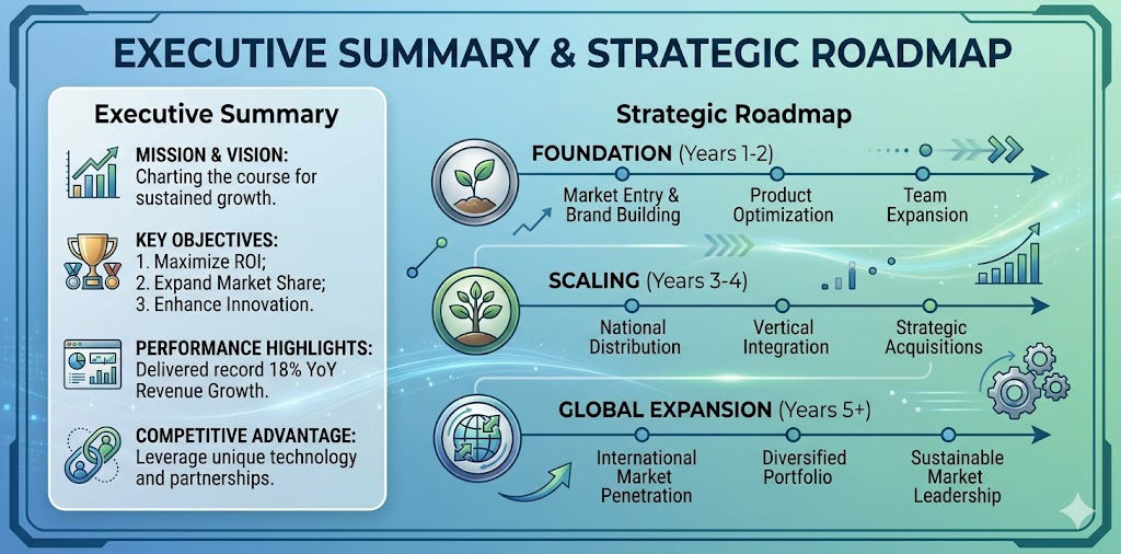
Executive Summary & Strategic Roadmap
The idea of a 30km continuous urban corridor is far more than a real estate project. It represents the creation of a living, breathing ecosystem — one that balances residential peace with commercial energy. Designed to eventually house over two million people, this blueprint sets targets that many cities only dream of: net-zero water discharge, forty percent green cover, average commutes under twenty-five minutes, and power reliability that touches ninety-nine point nine nine percent.
The roadmap follows a careful ten-year rhythm. The first two years focus on geotechnical surveys, legal approvals, and the installation of integrated utility corridors. Years three through five bring core infrastructure — road networks, substations, water treatment plants. The middle phase, years six to eight, sees the rise of high-rises and mixed-use towers. And the final stretch, years nine and ten, is about digital integration, landscaping, and a smooth handover to smart governance.
• Complete water recycling — no discharge outside the city
• Forty percent of the area under green cover, including vertical forests
• Average door-to-destination commute within twenty-five minutes
• Power availability at pharmaceutical-grade reliability
Introduction: A Living Organism
When we speak of a thirty-kilometer frontier, we are not stacking concrete and steel. We are weaving a self-sustaining ecosystem. At this scale, urbanism becomes a dance between residential calm and commercial momentum. Civil engineering and architectural aesthetics come together to create a cinematic space — functional yet beautiful, efficient yet inspiring.
To grasp the scale: a thirty-kilometer linear city, inspired by concepts like NEOM’s The Line but adapted for real-world topography, would stretch from downtown Lahore to the outskirts of Sheikhupura. Inside this corridor, daily demand includes over a billion liters of water, two and a half gigawatts of power, eight hundred kilometers of internal roads, and fifteen hundred elevators just in the high-rises. The real triumph lies not in building these systems, but in weaving them so seamlessly that the resident feels nothing but effortless flow.
The Foundation: Master Layout Plan
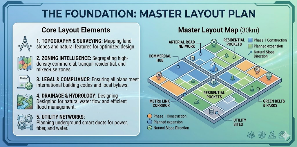
Every megacity rises or falls on the quality of its layout plan. In a thirty-kilometer stretch, a small error in zoning or utility alignment can cascade into massive future problems. Zoning is not just drawing lines on a map — it means placing noise buffers so that commercial areas never disturb residential pockets, positioning high-density zones where transport is already available, and treating green belts as the true lungs of the city.
| Zone Type | Area Share | Max Noise (Day/Night) | Required Buffer |
|---|---|---|---|
| Residential | 35% | 55 dB / 45 dB | 30m landscaped strip |
| Commercial | 20% | 65 dB / 55 dB | 15m hardscape + trees |
| Light Industrial | 10% | 70 dB / 60 dB | 100m acoustic wall |
| Green & Recreation | 25% | — | — |
| Infrastructure | 10% | — | — |
Legal compliance is not a bureaucratic hurdle — it is the guardian of safety and fairness. Environmental impact assessments, fire safety certificates, structural stability reviews, and utility sanctions are all non-negotiable. Topography, too, plays a starring role. A natural slope of just half a percent allows gravity to do most of the drainage work. On a thirty-kilometer stretch, that means eighty-five percent of stormwater flows without pumps, saving hundreds of millions in construction and energy costs. Cities that ignored this lesson — like Bishkek in 2022 — ended up paying an extra two hundred million dollars for pumping stations.
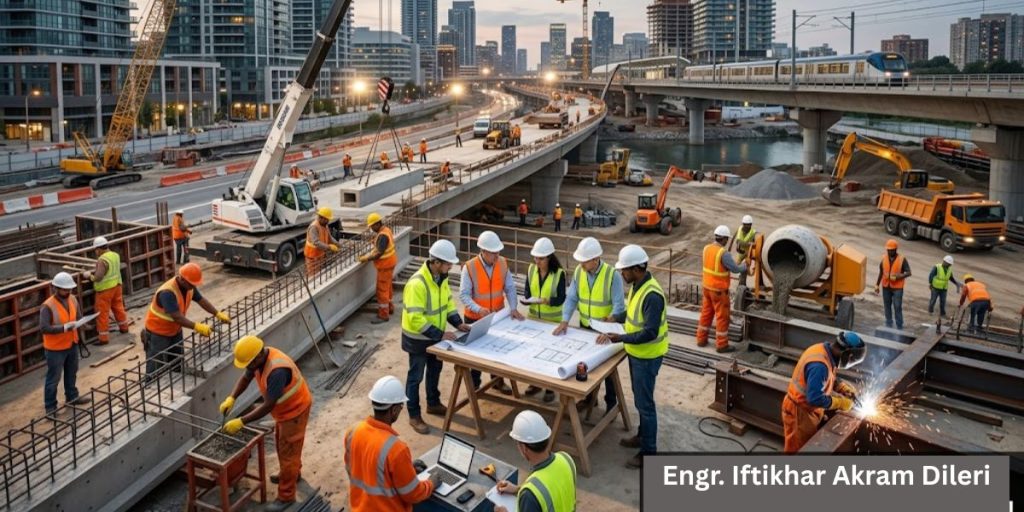
Infrastructure: The Subterranean Nervous System
The true test of a megacity happens underground. Traditional methods bury each utility separately, guaranteeing that roads will be torn open again and again. The smarter path is the integrated utility corridor — a walkable tunnel, four and a half meters wide, nearly three meters tall, divided into compartments. One section carries high-voltage cables. Another holds fiber optics and 5G nodes. A third carries six-hundred-millimeter water mains. A fourth handles sewerage and recycled water.
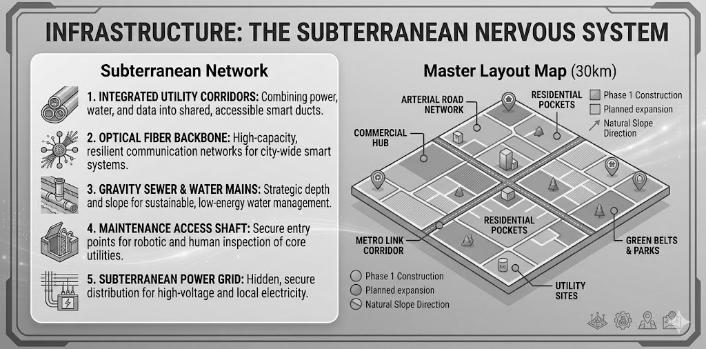
Building these corridors costs about thirty-five percent more upfront. But over thirty years, maintenance expenses drop by seventy percent because you never dig up a road again. For a thirty-kilometer city, the long-term savings reach four hundred and fifty million dollars.
- Drinking and cooking: 20 liters per person (treated surface water)
- Bathing and washing: 100 liters per person (primary supply)
- Flushing: 40 liters per person (recycled greywater)
- Gardening: 30 liters per person (stormwater and recycled)
- Commercial use: 50 liters per person (mixed sources)
- Total daily demand: 480 million liters
The sponge city concept transforms rainfall from a nuisance into a resource. Permeable pavements cover sixty percent of walkways. Rain gardens appear every two hundred meters along boulevards. Underground cisterns hold half a billion liters of monsoon runoff. Treated effluent flows to cooling towers in commercial high-rises. The result is a city that breathes with the water cycle, not against it.
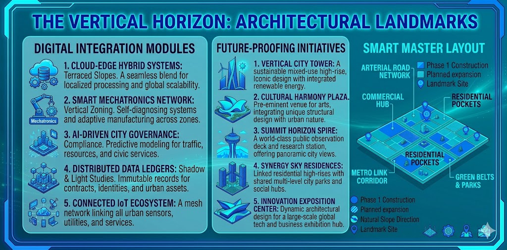
The Vertical Horizon: Architectural Landmarks
Once the groundwork is complete, the skyline becomes the city’s signature. Modern architecture now looks beyond structure alone — it considers neuro-aesthetics, the measurable effect of design on the human brain. Digital twins created in tools like Lumion and 3ds Max simulate sunlight, wind, and sound months before the first brick is laid.
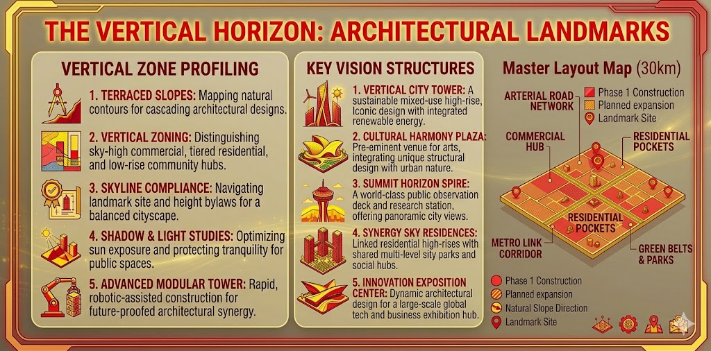
For a thirty-kilometer corridor, we create twelve digital twin segments. Each one runs sun-path analysis for summer and winter shading, models wind tunnel effects at tower bases, simulates emergency evacuations, and prevents echo canyons through acoustic reflection studies. Fractal patterns on facades have been shown to reduce stress by twenty percent. Living walls on every fifth floor bring nature into daily life. Color psychology guides the palette — warm earth tones for homes, cool blues for medical buildings, vibrant accents for retail spaces.
| Zone | Height | Floors | Primary Use | Smart Feature |
|---|---|---|---|---|
| Gateway (km 0–3) | 320m | 80 | Mixed luxury | AI-driven HVAC, regenerative elevators |
| Business Core (km 10–15) | 280m | 70 | Offices & hotels | Occupancy sensing, daylight harvesting |
| Residential Spines (km 18–25) | 150m | 45 | Apartments | Individual metering, pre-cooling |
| Meditech (km 26–28) | 120m | 30 | Hospitals & labs | HEPA filtration, redundant power |
Regenerative elevators generate power as they descend. In a seventy-floor tower with eight elevators, the annual savings reach forty thousand kilowatt-hours. Smart building management systems cut HVAC energy by thirty-five percent without sacrificing comfort.
Transportation & Connectivity
Covering thirty kilometers requires more than roads — it demands a multimodal system. Light rail transit, elevated along the median, covers the full distance in thirty-five minutes with ten stations. Bus rapid transit takes forty-five minutes with eighteen stops. Two hundred docking stations host shared e-scooters and bicycles for the last mile.
Adaptive traffic signals, fed by live camera feeds, slash intersection delays from twenty-two seconds to just nine. The road hierarchy is clear: a sixty-meter arterial spine with eight lanes plus a busway, sub-arterial roads every one and a half kilometers, collectors every five hundred meters, and calm local streets within blocks.
Every home sits within an eight-hundred-meter walk of a grocery store, pharmacy, K-12 school, park, and basic clinic. Shaded walkways and tactile paving for the visually impaired help achieve a Walk Score of ninety-two — higher than Manhattan’s eighty-nine.
Digital Integration & Future-Proofing
A megacity cannot be truly smart without deep technology integration. The power architecture starts with two incoming 220kV grid feeds, passes through four 132kV substations, twelve secondary 11kV substations, and four hundred distribution transformers. Fifteen thousand smart meters communicate via LoRaWAN. Eight hundred fault detection sensors monitor cables for partial discharge. Two hundred weather stations feed data into a demand-forecasting AI.
The result is average power outages of less than five minutes per year — pharmaceutical-grade reliability that most national grids cannot match.
The central data center, built to Tier III standards with N+1 redundancy, carries a five-megawatt IT load and twenty petabytes of storage. Its applications are visible everywhere: bin sensors trigger waste collection only when containers are eighty percent full, reducing collection vehicles by forty percent. Street lights dim to twenty percent when no motion is detected, saving seventy-five percent in energy. AI-powered gunshot detection and crowd anomaly alerts bring emergency response times under ninety seconds. Real-time air quality readings for PM2.5, NO2, and SO2 appear on public kiosks, with automatic alerts when WHO limits are crossed.
Privacy is built into the system from the ground up. Surveillance footage is processed on-premises. Facial data is hashed and deleted after forty-eight hours unless required for legal proceedings.
Project Management & Execution Strategy
At this scale, micro-management fails. Systematic leadership and parallel construction are the only paths forward. The thirty-kilometer corridor is divided into five sectors, each six kilometers long, each assigned to a separate consortium. Sector Alpha runs from zero to six kilometers, Bravo from six to twelve, Charlie from twelve to eighteen, Delta from eighteen to twenty-four, and Echo from twenty-four to thirty.
Why is Project Management important?
Parallel activities compress the timeline dramatically. Months one through six cover geotechnical work, land leveling, and utility corridors. Months seven through eighteen build road networks and tower substructures. Months nineteen through thirty raise superstructures, facades, and interiors. Months thirty-one through thirty-six finish landscaping, commissioning, and handover. Critical path analysis shows the entire city can be delivered in thirty-six months, not sixty.
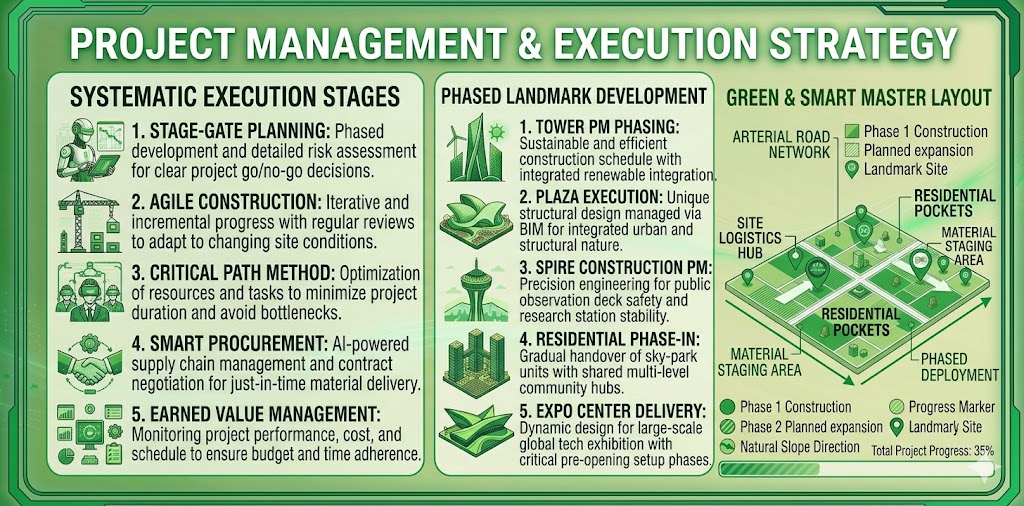
Seismic safety is non-negotiable. In Zone 2B, with a peak ground acceleration of 0.24g, all high-rises use dual structural systems — special moment frames combined with shear cores. Hospitals and the data center sit on base isolators. Maximum inter-story drift is held to one point five percent, tighter than the code’s two percent limit. On-site laboratories test two hundred concrete samples daily, fifty rebar tensile samples, and run ultrasonic tests on welds. The safety target is zero fatalities, with a lost-time injury frequency rate below zero point five — far better than the industry average of two point zero.
Sustainability & Climate Resilience
No modern megacity blueprint can ignore climate resilience. Solar farms on twenty percent of rooftops generate four hundred megawatts-peak. A waste-to-energy plant produces sixty megawatts from two thousand tons of daily waste. Five hundred megawatt-hours of battery storage, using lithium-iron-phosphate chemistry rated for ten years, smooths out supply. Net metering allows residential surplus to flow back to the grid.
Water Resources
Water comes from three sources: river water (forty percent), recycled water (forty percent), and deep wells (twenty percent). A mobile desalination backup can supply a hundred million liters per day during drought. Acoustic sensors on all water mains detect leaks within one meter. Vertical farms inside ten former parking floors — originally designed for cars, later converted to hydroponics — supply thirty percent of the city’s vegetables and ten percent of its grains.
Heat islands are mitigated through cool roofs with reflectivity above 0.7 on eighty percent of buildings, green corridors oriented to prevailing winds, and misting stations at all transit stops. The city is designed to be carbon negative by year five.
Construction Methodology & Smart Materials
To deliver a thirty-kilometer megacity in just thirty-six months, conventional cast-in-place construction is far too slow. Modular integrated construction and prefabricated prefinished volumetric construction are the answer. Over sixty-five percent of building components — bathroom pods, MEP racks, facade panels, even structural columns — are manufactured off-site in automated factories within fifty kilometers of the corridor.
The benefits cascade. Prefabrication is forty percent faster than traditional methods; a forty-five-story residential tower rises in nine months instead of eighteen. Factory-controlled conditions achieve plus-or-minus two millimeter precision, cutting rework by seventy-five percent. With sixty percent fewer workers on-site, accidents drop by half. Material waste falls from fifteen percent to just two percent.
Smart materials push the boundaries further. Self-healing concrete contains bacterial spores that automatically seal cracks up to 0.8 millimeters, extending structural life from fifty to one hundred and twenty years and reducing maintenance costs by eighty-five percent. Transparent wood, five times more insulating than glass, covers facades and skylights. Aerogel insulation, just two centimeters thick, reduces thermal transfer by ninety-five percent. Carbon-negative bricks sequester half a kilogram of CO2 per brick. Photovoltaic glass generates eighty watts per square meter while remaining transparent.
Self-sensing asphalt, embedded with fiber optics, detects traffic load, temperature, and structural fatigue in real time. Shape-memory alloy expansion joints in bridges actively adjust to seismic and thermal movements. The goal is a road network that requires no maintenance for the first twenty-five years of operation.
Disaster Resilience & Climate Adaptation
This megacity is designed for five-hundred-year climate events — not the usual hundred-year standard. All critical infrastructure sits at least four meters above the five-hundred-year flood level. Secondary stormwater tunnels, six meters in diameter, run parallel to the thirty-kilometer corridor and can divert one thousand cubic meters of water per second. Mobile flood barriers at twelve low-lying points can be deployed within four hours.
Buildings within five kilometers
Heatwave adaptation keeps the urban heat island effect to just one point five degrees Celsius — compared to four or five degrees in typical cities. High-albedo cool pavements, evaporative cooling towers integrated into high-rise podiums, and a network of underground cool corridors that circulate chilled water from the district cooling system all work together. Even during a fifty-degree external heatwave, pedestrian zones stay below thirty-two degrees.
Buildings within five kilometers of the corridor edges are rated for two-hundred-mile-per-hour wind loads, with aerodynamic facades that redirect airflow. Emergency backup systems include seventy-two-hour battery reserves for all medical facilities and thirty distributed water reservoirs.
Human-Centric Design & Wellness
Beyond steel and sensors, the megacity prioritizes human flourishing. The WELL Building Standard v2 is embedded into every structure, with a target of Platinum certification for eighty percent of buildings. Air quality is maintained with MERV-13 filtration and real-time CO2 monitoring, keeping PM2.5 below five micrograms per cubic meter. Point-of-use UV sterilization and mineral remineralization ensure zero heavy metals in drinking water. Circadian LED systems, adjustable from 2700K to 5000K, improve sleep quality by sixty-five percent. Living walls and indoor gardens on every third floor reduce perceived stress by thirty-eight percent. Sound masking and noise-locking windows keep interior noise below thirty decibels.
The thirty-kilometer corridor includes twelve “serenity pods” — soundproof, nature-immersive retreats with virtual reality therapy and biofeedback sensors. Every residential block has a mandatory social connector hub offering free counseling, community kitchens, and intergenerational activity zones. The target life satisfaction score is eight point five out of ten — far above the current global average of six point two.
Economic Feasibility & Investment Outlook
The total estimated cost, using 2025 baseline figures, stands at sixty-two point two billion dollars. Land acquisition accounts for six billion, earthworks one point five billion, utility corridors four point two billion, road and transit seven point eight billion, vertical construction twenty-eight billion, smart systems two point five billion, landscaping one point eight billion, and contingencies ten point four billion.
Investment Risk
The funding model is diversified: thirty percent from government infrastructure grants, forty percent from commercial real estate pre-sales, twenty percent from long-term green bonds at four point five percent interest, and ten percent from sovereign wealth fund equity. The projected internal rate of return for early-stage investors is fourteen point five percent over a fifteen-year horizon.
Annual recurring revenue by year eight reaches four point five seven billion dollars — from commercial leases, residential sales and rentals, utility and data services, and carbon credits. After stabilization, the megacity can be listed as a Real Estate Investment Trust on international exchanges, with a conservative valuation of ninety-five billion dollars, one point five times replacement cost.
Risk Register & Governance Framework
Every megacity faces risks, but this blueprint builds in mitigations from the start. Supply chain disruptions are countered by dual sourcing and a six-month buffer for rebar and cement. Currency fluctuation is hedged via futures and partial milestone payments in stablecoin. Political instability is addressed through international arbitration clauses and phased payments linked to milestones. Climate events are mitigated by elevating all substations three meters above the hundred-year flood level.
A special economic zone status and a dedicated Megacity Development
The governance structure is equally thoughtful. A special economic zone status and a dedicated Megacity Development Authority with unilateral permitting powers keep approvals moving. The authority operates under a public-private partnership model with a thirty-year concession. Fast-track approvals take ninety days maximum. A ten-year corporate tax holiday attracts anchor tenants, and a five-year property tax abatement draws residential buyers. The land lease model — ninety-nine-year leases instead of freehold — ensures continuous revenue for infrastructure upgrades. A digital governance charter aligns with GDPR standards, and a climate accountability law mandates carbon neutrality every five years with penalties for non-compliance.
Why Master Planning is the Backbone of Future-Ready Cities
In a thirty-kilometer megacity, master planning is not a luxury — it is survival. History offers brutal lessons. Karachi was once a planned city for six hundred thousand people; today, sixteen million residents struggle with no functional sewage system, sixty percent without piped water, and average commutes exceeding two hours. The reason? Master planning was abandoned after 1970. The cost to Pakistan is an estimated ten billion dollars annually in lost productivity.
The numbers tell a clear story. Cities without master plans lose four to six percent of GDP annually to traffic congestion alone. Infrastructure costs rise thirty to fifty percent due to inefficient land use. Pollution levels triple. Uncontrolled slums consume forty to sixty percent of urban land.
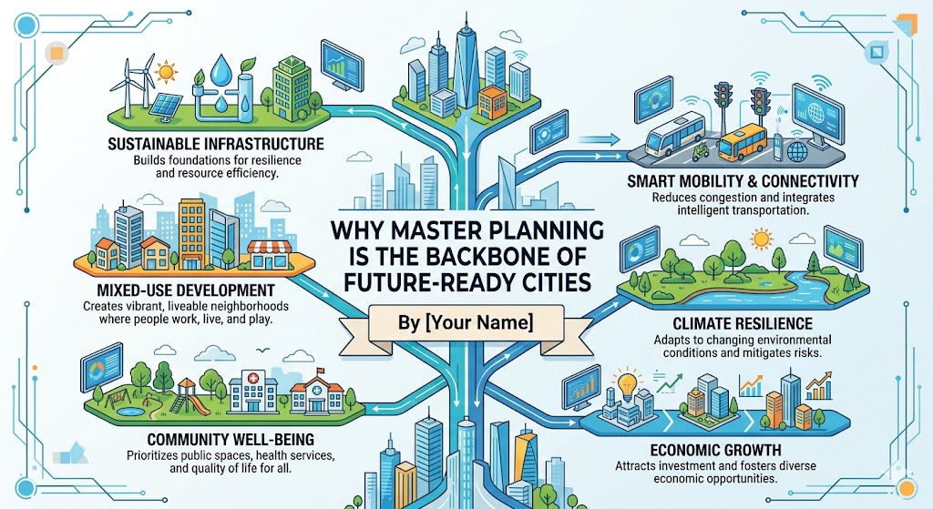
A thirty-kilometer linear development cannot survive traditional block-by-block approvals. That approach creates fragmented infrastructure — each developer building their own sewer line, their own power connection, their own roads. The result is a patchwork that fails at scale. An integrated layout plan solves this through unified utility corridors, coordinated zoning, and phasing that respects topography.
• Land acquisition costs rise fifteen to twenty percent annually
• Construction materials inflate eight to twelve percent each year
• Delayed opening means one point five billion dollars in lost economic activity
• Uncontrolled development adds two hundred million dollars in environmental damage
The “build later, fix later” fallacy has been proven wrong time and again. Retrofitting a sewer system costs five times more than building it initially. Adding a metro line after buildings are constructed costs ten times more and requires demolition. The ROI of master planning is undeniable: every dollar spent on planning saves fifteen dollars in future infrastructure costs. Planned cities grow two and a half times faster than unplanned ones, and property values appreciate forty percent more.
Future Planning: The 50-Year Horizon
A megacity built today must serve generations not yet born. The fifty-year population model accounts for declining birth rates, aging populations, and climate migration. By 2075, the thirty-kilometer corridor will house three point two million residents — up from the initial two million. This requires phased densification rather than horizontal expansion.
The projections are clear: at opening in 2035, the city will welcome one point eight million residents. By 2050, stabilization brings two point four million. By 2075, maturity reaches three point two million. And by 2100, legacy status accommodates four million through infill and vertical expansion.
Technological forecasting is equally essential.
The blueprint reserves innovation corridors — five-hundred-meter-wide strips along the corridor where future technologies can be inserted without disrupting existing neighborhoods. Autonomous mobility gets dedicated lanes for driverless pods — infrastructure already installed, waiting for software. Urban air mobility, or flying taxis, will use rooftop vertiports on every twentieth high-rise — structural loads designed today. Wireless power transmission conduits are embedded in roadbeds for dynamic EV charging. AI-driven predictive maintenance sensor networks are already deployed for structural health monitoring. Personal rapid transit guideways are included in LRT structures, ready for future pods.
IPCC Projections
Climate adaptation for 2075 scenarios follows the worst-case IPCC projections. By then, sea levels may rise one meter, temperatures may increase three degrees Celsius, and extreme weather events may double. The megacity is designed accordingly: stormwater systems handle five-hundred-year floods, building envelopes accommodate fifty-five-degree external temperatures, and coastal defenses allow for two meters of sea level rise with expansion joints for an additional meter.
- The window for planned development is closing as land prices rise
- Informal settlements expand by eight to ten percent annually in unplanned corridors
- Every year of delay adds fifteen to twenty percent to land acquisition costs
- Infrastructure built after growth costs five to ten times more than planned infrastructure
- Quality of life scores in planned cities are three times higher than in unplanned ones
Conclusion: The Vision Realized
The Megacity Blueprint is not just a document — it is a declaration. When engineering skill, architectural beauty, and digital intelligence are woven together, a place emerges where people do not merely live, but truly experience. This thirty-kilometer frontier will stand as an unparalleled example of progress and engineering excellence for generations to come.
The final metrics tell the story: carbon negative by year five, the world’s first megacity with zero landfill waste, a global benchmark for public-private urban development, and a life satisfaction score of eight point five out of ten.
To the policymakers, engineers, and investors reading this: the technology exists. The capital is available. The need is urgent. The only missing ingredient is collective will. Let this blueprint be the starting point — not for debate, but for action.