
By 2026, the digital landscape will no longer be a separate layer of our existence; it has become the very fabric of how we design, build, and interact with the physical world. The “Infrastructure of Tomorrow” is being realized through a powerful trinity of technologies: Geographic Information Systems (GIS), Hitachi’s enterprise ecosystems, and Advanced AI Chatbots
Digital World 2026: The Synergy of GIS, Hitachi Systems, and AI Chatbots
GIS
Geographic Information Systems
Hitachi
Lumada & Edge Computing
AI Chatbot
LLM & RAG Technology
Micro GIS
Sub-meter Accuracy
.Historically, these fields operated in silos. Civil engineers used GIS for mapping, IT departments managed Hitachi servers for data storage, and customer service teams utilized basic chatbots. Today, that boundary has dissolved. We have entered an era of Interoperability, where a high-voltage grid station can be monitored via a digital twin, optimized by Hitachi Lumada algorithms, and queried in plain Urdu or English by a site engineer using a conversational AI interface.
🗺️ 1. The Precision Revolution: GIS and Micro GIS

The foundation of any smart infrastructure is location intelligence. In 2026, the shift from Macro to Micro GIS has redefined accuracy. While traditional GIS dealt with regional planning and topography, Micro GIS operates at the sub-meter level, mapping the interior of buildings, the exact depth of underground utility lines, and the precise placement of structural components.
What is Geographic Information Systems (GIS)?
GIS is a framework for gathering, managing, and analyzing spatial data. It integrates many types of data layers using spatial location, organizing layers of information into visualizations using maps and 3D scenes. In 2026, GIS has evolved from static mapping to real-time dynamic spatial intelligence.
Micro GIS: Mapping at Sub-Meter Accuracy
Traditional GIS provided accuracy within meters — sufficient for city planning but inadequate for modern construction. Micro GIS uses high-resolution satellite imagery, drone scanning, and ground-penetrating radar to achieve centimeter-level accuracy. This precision allows engineers to:
- Map underground utilities before digging — preventing costly strikes
- Monitor structural deformation of buildings and bridges
- Track the exact placement of reinforcement steel and embedded sensors
- Create detailed as-built drawings automatically
BIM-GIS Integration: The New Standard
The integration of Building Information Modeling (BIM) with GIS allows for a “cradle-to-grave” view of a project. During the design phase, architects use GIS to analyze soil resistivity, seismic risks, and environmental impact. During construction, Micro GIS tracks the real-time movement of machinery and materials. For a multidisciplinary professional, this means the ability to visualize a 72-story luxury tower not just as a 3D model, but as a living entity positioned accurately within its global environment.
Key GIS Technologies in 2026
- Geospatial Intelligence (GEOINT): Analyzing satellite imagery for terrain and infrastructure changes
- Digital Twin Technology: Virtual replicas of physical assets that update in real-time
- Spatial Data Infrastructure (SDI): Frameworks for sharing geospatial data across organizations
- 3D City Modeling: Complete digital representations of urban environments
- Real-time Sensor Integration: Live data from IoT sensors overlaid on maps
For more on digital infrastructure, read our article on Why Structural Integrity Saves Lives.
🏭 2. Hitachi Systems: The Backbone of Industrial Reliability
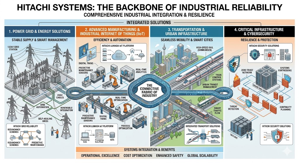
If GIS is the eyes of the digital world, Hitachi Systems represent the nervous system and the muscle. Hitachi has transitioned from being a hardware giant to a leader in Social Innovation Business, providing the hybrid cloud infrastructure and IoT platforms (like Lumada) necessary to process the massive datasets generated by modern cities.
Hitachi Lumada: The Industrial IoT Platform
Hitachi Lumada is an advanced digital platform that uses AI and IoT to turn operational data into actionable insights. In 2026, Lumada is the backbone of smart manufacturing, energy management, and urban infrastructure. Its capabilities include:
- Data Integration: Connecting sensors, machines, and systems across different vendors
- Predictive Analytics: Forecasting equipment failures before they happen
- Edge Computing: Processing data at the source for real-time decisions
- Digital Twins: Creating virtual replicas of physical industrial assets
Smart Grids and Energy Solutions
In the realm of civil engineering and power distribution, Hitachi’s role is critical. The construction of 138kV grid stations now relies on Hitachi’s predictive maintenance tools. By analyzing data from sensors embedded in transformers and transmission lines, the system can predict a fault before it occurs. This “Self-Healing Grid” concept is powered by Hitachi’s ability to process Big Data at the edge — meaning data is analyzed right at the grid station rather than waiting for it to travel to a central server.
Key Hitachi Technologies in 2026
- Hitachi Lumada: IoT platform for industrial digital transformation
- Edge Computing: Processing data at the source — milliseconds matter
- Predictive Maintenance: AI-driven forecasts of equipment failure
- Industrial IoT (IIoT): Connected sensors and machinery
- Hybrid Cloud Infrastructure: Secure, scalable data storage
Check out our guide on Using Thermal Imaging to Monitor Electrical Equipment.
🤖 3. AI Chatbots: The New Interface for Engineering

The most significant change in 2026 is how we interact with technology. We are moving away from complex dashboards and toward Conversational Interfaces. AI Chatbots, powered by Large Language Models (LLMs) and Retrieval-Augmented Generation (RAG), have become the primary “Project Management Assistants”.
What Makes 2026 AI Chatbots Different?
Unlike the rule-based chatbots of the past, modern AI chatbots understand context, intent, and nuance. They can:
- Understand natural language: “Show me the foundation schedule for Building C” works even if phrased conversationally
- Access multiple data sources: Pulling from project management software, GIS maps, and equipment sensors
- Generate reports: Automatically create daily progress summaries or safety checklists
- Speak multiple languages: Urdu, English, Punjabi, Arabic — bridging communication gaps on diverse sites
The Technical Site Assistant in Action
Imagine a Site Engineer standing in the middle of a canal rehabilitation project. Instead of flipping through hundreds of pages of PDF blueprints, they simply ask a chatbot: “What is the concrete pouring schedule for Section B-4, and does it align with the current weather forecast?” The AI, connected to the GIS for location data and Hitachi’s servers for project schedules, provides an instant, accurate answer. It can even generate a daily progress report or a safety checklist in Urdu, Punjabi, or English, bridging the communication gap between stakeholders and the workforce.
Key AI Chatbot Technologies in 2026
- Natural Language Processing (NLP): Understanding human language with context
- Retrieval-Augmented Generation (RAG): Combining AI knowledge with your specific project data
- Intent Recognition: Understanding what the user wants, not just keywords
- Semantic Search: Finding information based on meaning, not exact words
- Multimodal AI: Understanding text, images, voice, and video inputs
Read our insights on Whistleblower Engineers: Stories of Courage in Construction.
🔗 4. The Synergy: How GIS, Hitachi, and AI Work Together

⚡ The Three-Pillar Convergence
🗺️ GIS (Location Intelligence) → 🏭 Hitachi (Industrial IoT) → 🤖 AI Chatbot (Conversational Interface)
↓ Detection → Analysis → Action ↓
Result: Response time reduced from hours to seconds
The true magic happens when these three pillars converge. Let’s look at a practical use case: Smart City Disaster Management.
Use Case: Flood Response in Urban Infrastructure
- Detection (GIS): Satellite imagery and Micro GIS sensors detect a rising water level in a major canal or a thermal anomaly in a grid station. The system identifies the affected area and critical infrastructure at risk.
- Analysis (Hitachi): Hitachi’s Lumada platform ingests this geospatial data, compares it with historical flood patterns, and simulates to determine the risk of structural failure. It predicts which bridges and roads are likely to be compromised within the next 2 hours.
- Action (AI Chatbot): The system automatically alerts the Project Head via a chatbot. The engineer asks, “Show me the nearest evacuation routes and the location of the emergency shut-off valves.” The AI instantly pulls the Micro GIS map, overlays real-time traffic data, and displays the safest route on the engineer’s device.
Other Synergy Applications
- Transmission Line Monitoring: GIS maps tower locations, Hitachi sensors monitor vibration and tension, AI chatbot alerts engineers to anomalies
- Construction Quality Control: Micro GIS tracks concrete pour locations, Hitachi analyzes curing sensor data, AI chatbot generates daily compliance reports
- Equipment Maintenance: GIS tracks equipment locations, Hitachi predicts failures, AI chatbot schedules maintenance and orders parts
Learn more from The GDAC Scandal: How Infrastructure Theft is Caught with Digital Tools.
💼 5. Digital Entrepreneurship and the Future of Work

For firms like Madina Construction Technologies, this digital shift is an opportunity for branding and growth. In 2026, an engineering firm isn’t just judged by its physical projects, but by its Digital Maturity.
SEO and Global Reach in the Digital World
As businesses move online, SEO and Content Marketing for the engineering sector have become specialized. Highlighting expertise in “Seismic-Resistant Design” or “Mechatronics in Civil Engineering” through data-driven articles helps firms attract international consultants and investors. The “Digital World” allows a firm based in Lahore to provide architectural drafting or interior design services to clients in Dubai, London, or New York, provided their digital infrastructure is robust.
Emerging Digital Professions in 2026
- Digital Twin Engineer: Creates and maintains virtual replicas of physical assets
- AI Prompt Engineer for Construction: Specializes in training AI chatbots for site-specific needs
- Geospatial Data Analyst: Extracts insights from GIS and satellite imagery
- Industrial IoT Architect: Designs sensor networks for infrastructure monitoring
Read our Exclusive Interview with Aryan: The Real Iron Sentinel for digital transformation insights.
🔒 6. Challenges: Security, Ethics, and Implementation
With great data comes great responsibility. The 2026 Digital World faces significant challenges that must be addressed proactively.
Cybersecurity Risks
A GIS system that maps a city’s underground utilities is a goldmine for bad actors. Similarly, AI Chatbots must be guarded against “hallucinations” and data breaches. Key security measures include:
- Zero Trust Architecture: Verify every user and device before granting access
- Blockchain-Verified Geospatial Data: Ensuring that location data cannot be tampered with
- End-to-End Encryption: Protecting data in transit and at rest
- Regular Security Audits: Testing systems for vulnerabilities
Ethical Considerations for AI
- Bias in AI Models: Ensuring chatbots treat all users fairly
- Data Privacy: Protecting personal and location data of individuals
- Transparency: Users should know when they are interacting with an AI
- Accountability: Clear responsibility for AI-driven decisions
Implementation Challenges
- Skills Gap: Shortage of professionals trained in GIS, IoT, and AI
- Integration Costs: Initial investment in hardware and software
- Legacy Systems: Older infrastructure may not be compatible with new digital tools
- Change Management: Getting teams to adopt new workflows
🚀 7. Future Predictions: Beyond 2026

What comes after 2026? The convergence of GIS, Hitachi systems, and AI chatbots is just the beginning. Here’s what experts predict for the next decade:
Autonomous Infrastructure
By 2030, we expect fully autonomous construction sites. AI will not just answer questions — it will make decisions. Drones and robots will perform site inspections, adjust concrete pours, and reroute logistics without human intervention.
Artificial General Intelligence (AGI)
While today’s AI excels at specific tasks, AGI will match human intelligence across domains. An AGI site manager could handle engineering calculations, contract negotiations, safety oversight, and team communications autonomously.
Quantum Computing for Spatial Analysis
Quantum computers will process GIS data millions of times faster than today. Complex urban simulations that currently take days will run in seconds, enabling real-time city management.
Brain-Computer Interfaces (BCI)
Early BCI devices will allow engineers to query digital systems with their thoughts. “Think” a command, and the AI chatbot responds — no typing, no speaking.
Learn about current applications in Love Under Construction: Romance on the Job Site.
With great data comes great responsibility. The 2026 Digital World faces significant challenges in Cybersecurity. A GIS system that maps a city’s underground utilities is a goldmine for bad actors. Similarly, AI Chatbots must be guarded against “hallucinations” and data breaches.
✅ 8. Conclusion: Building the Tomorrow, Today
Digital World 2026 is not a distant dream; it is the reality we are constructing with every line of code and every cubic meter of concrete. The synergy of GIS, Hitachi Systems, and AI Chatbots represents the ultimate toolset for the modern multidisciplinary professional.
Whether you are supervising a 138kV grid station, managing a massive canal rehabilitation, or designing a high-rise tower, these technologies empower you to work smarter, safer, and more efficiently. We are no longer just builders of structures; we are architects of integrated digital ecosystems.
The infrastructure of tomorrow is sustainable, smart, and resilient. And most importantly, it is an infrastructure that finally speaks our language.
Are you ready for the Digital World 2026? Start your digital transformation today.
🔗 Internal Resources (Madina Construction Technologies)
- 1. Why Structural Integrity Saves Lives
- 2. Grade-60 Rebar Specifications for Construction
- 3. Using Thermal Imaging to Monitor Electrical Equipment
- 4. Whistleblower Engineers: Stories of Courage in Construction
- 5. The GDAC Scandal: How Infrastructure Theft is Caught with Digital Tools
- 6. Love Under Construction: Romance on the Job Site
- 7. Exclusive Interview with Aryan: The Real Iron Sentinel
🌐 External Standards & References (High Authority)
🔨 At Madina Construction Technologies, we embrace the Digital World 2026 — GIS, Hitachi Systems, and AI Chatbots
Ready to bring digital transformation to your next project?
👉 Contact Our Digital Solutions Team Today